 Rubii: AI Character Community

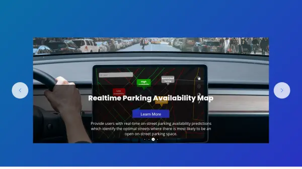

What is Parknav?
Parknav leverages advanced artificial intelligence, big data analysis, and patented data science technologies to deliver highly accurate parking information. It processes a vast array of real-time and historical data from sources including automobile sensors, cell phone towers, weather patterns, satellite imagery, traffic data, and proprietary inputs to achieve industry-leading precision in its predictions.
The platform offers a comprehensive suite of parking solutions, including real-time predictions for on-street parking availability, detailed information on parking restrictions (specifying where, what type, and when they apply), and turn-by-turn voice-guided navigation to guide users directly to available on-street or off-street parking spots. This service covers over 1000 cities across North America and Europe, catering to individual drivers, businesses, and smart city initiatives.
Features
- Real-time Parking Availability Map: Predicts and displays streets with high probability of open on-street parking.
- Parking Restrictions Information: Provides detailed data on parking rules, times, and locations.
- Turn-By-Turn Parking Navigation: Offers voice-guided routes directly to available on-street and off-street parking.
- AI and Data Science Innovation: Employs AI and big data for high precision parking predictions (80% benchmark).
- Extensive City Coverage: Operates in over 1000 cities across North America and Europe.
- Navigation SDK: Allows integration of parking navigation into third-party applications.
- Parking Analytics: Provides insights based on parking data for cities and businesses.
Use Cases
- Finding available street parking in real-time.
- Checking parking rules and time restrictions before leaving the car.
- Navigating efficiently to the nearest predicted open parking space.
- Integrating real-time parking data into vehicle navigation systems.
- Developing smart city solutions for traffic and parking management.
- Providing parking information services for mobility apps.
- Analyzing parking patterns for urban planning and real estate development.
FAQs
-
What kind of data does Parknav use for its predictions?
Parknav processes real-time and historical data from diverse sources like automobile sensors, cell phone towers, weather sensors, car-sharing fleets, mapping providers, satellite imagery, traffic patterns, real estate data, city information, and proprietary sources. -
How accurate are Parknav's parking predictions?
Parknav utilizes advanced AI and data science, aiming for an industry benchmark of 80% precision in predicting parking availability for every city it covers. -
How many cities does Parknav cover?
Parknav provides parking data and services for over 1000 cities located in North America and Europe. -
Does Parknav offer navigation to parking spots?
Yes, Parknav offers real-time, turn-by-turn voice-guided navigation directing users to predicted open on-street and available off-street parking spaces through its mobile app and Navigation SDK. -
Is Parknav suitable for businesses and developers?
Yes, Parknav offers solutions for various industries including Automotive, Mobility, Real Estate, and Cities, providing APIs and SDKs for integration.
Related Queries
Helpful for people in the following professions
Parknav Uptime Monitor
Average Uptime
99.85%
Average Response Time
314.9 ms

Featured Tools
Join Our Newsletter
Stay updated with the latest AI tools, news, and offers by subscribing to our weekly newsletter.